It was late, and I didn't have time to finish the post for day 1...
After getting back to the room for a rest, we decided to head south. I had found Tomb of the Eagles on the map, so we decided to drive in that direction until it got late. My dad didn't want to drive after dark, plus he probably just wanted to go to bed after dark. As it turned out, he was getting sick, so we probably should have just skipped that jaunt, but we saw part of the island we wouldn't seen otherwise, and I really love some of these photos. You know me - I've just got to see everything. And good photos are a bonus.

Off the southeastern tip of Orkney, is a string of several small islands. They are connected by causeways, so you can drive to the southern tip of them.

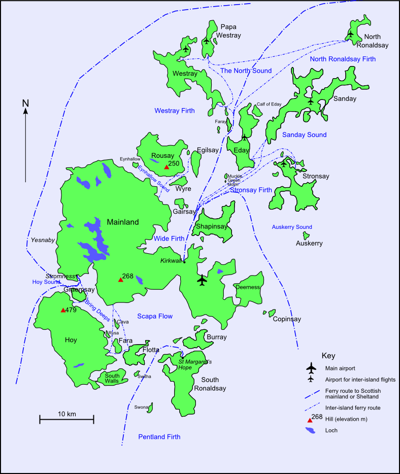
During The Great War, The British Grand Fleet was based in Scapa Flow. Okay, check out this map. Mainland Orkney, the big island in the middle. Hoy, to the lower left. Our ferry Came up the middle into the big bay called Scapa Flow, and then turned left and went up to Stromness. We were staying Kirkwall, so that's where we drove out of, for this jaunt. Anyway, The Fleet was understandably nervous about German U-boats. They tried to block the entrances to Scapa Flow with mines and nets, and the sunk "blockships" in the channels to try to stop the U-boats. There were no successful attacks in the harbour.

But in 1939, a U-boat got through, and sunk a battleship, resulting in the loss of over 800 people. Churchill ordered the construction of a more solid barrier. It was begun the following year, and the "Churchill Barriers" were officially opened four days after the end of the war in Europe. You can see one of the causeways to the right of the remains of the blockship.


Pentland Skerries lighthouse.
Seeking Tomb of the Eagles, we turned off of the main road. I didn't realize we were as close as we were to the tip of the island, or I might have suggested we go there, just to see it. The Tomb was closed, but we thought we'd walk out to see it anyway. At least the visitor center was closed. Not sure if the tomb itself was locked. But we had no torch, so we couldn't have seen anything anyway.

But there were scenic cliffs.

See the little black specks in the water?...

Seals.

It turned out to be a lot longer walk than we expected, so we turned back.

My dad, of course, with Pentland Skerries again. And sheep.


After getting back to the room for a rest, we decided to head south. I had found Tomb of the Eagles on the map, so we decided to drive in that direction until it got late. My dad didn't want to drive after dark, plus he probably just wanted to go to bed after dark. As it turned out, he was getting sick, so we probably should have just skipped that jaunt, but we saw part of the island we wouldn't seen otherwise, and I really love some of these photos. You know me - I've just got to see everything. And good photos are a bonus.
Off the southeastern tip of Orkney, is a string of several small islands. They are connected by causeways, so you can drive to the southern tip of them.
During The Great War, The British Grand Fleet was based in Scapa Flow. Okay, check out this map. Mainland Orkney, the big island in the middle. Hoy, to the lower left. Our ferry Came up the middle into the big bay called Scapa Flow, and then turned left and went up to Stromness. We were staying Kirkwall, so that's where we drove out of, for this jaunt. Anyway, The Fleet was understandably nervous about German U-boats. They tried to block the entrances to Scapa Flow with mines and nets, and the sunk "blockships" in the channels to try to stop the U-boats. There were no successful attacks in the harbour.
But in 1939, a U-boat got through, and sunk a battleship, resulting in the loss of over 800 people. Churchill ordered the construction of a more solid barrier. It was begun the following year, and the "Churchill Barriers" were officially opened four days after the end of the war in Europe. You can see one of the causeways to the right of the remains of the blockship.
Pentland Skerries lighthouse.
Seeking Tomb of the Eagles, we turned off of the main road. I didn't realize we were as close as we were to the tip of the island, or I might have suggested we go there, just to see it. The Tomb was closed, but we thought we'd walk out to see it anyway. At least the visitor center was closed. Not sure if the tomb itself was locked. But we had no torch, so we couldn't have seen anything anyway.
But there were scenic cliffs.
See the little black specks in the water?...
Seals.
It turned out to be a lot longer walk than we expected, so we turned back.
My dad, of course, with Pentland Skerries again. And sheep.
no subject
Date: 2014-05-07 09:22 am (UTC)From:no subject
Date: 2014-05-08 01:00 am (UTC)From:no subject
Date: 2014-05-07 02:50 pm (UTC)From: